
Thank you for supporting this site ❤️
Make a donation
Make a donation
Belgut topographic map
Click on the map to display elevation.
Thank you for supporting this site ❤️
Make a donation
Make a donation
About this map
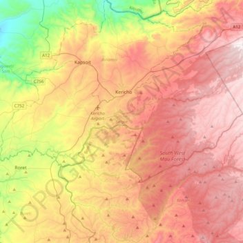
Name: Belgut topographic map, elevation, terrain.
Location: Belgut, Kericho County, Rift Valley, 20205, Kenya (-0.51155 35.08429 -0.31699 35.47414)
Average elevation: 1,960 m
Minimum elevation: 1,302 m
Maximum elevation: 2,520 m
Thank you for supporting this site ❤️
Make a donation
Make a donation
Other topographic maps
Click on a map to view its topography, its elevation and its terrain.