
Kailash topographic map
Interactive map
Click on the map to display elevation.
About this map
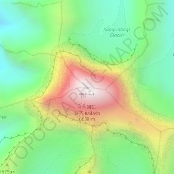
Name: Kailash topographic map, elevation, terrain.
Average elevation: 5,753 m
Minimum elevation: 5,228 m
Maximum elevation: 6,585 m
Other topographic maps
Click on a map to view its topography, its elevation and its terrain.
མངའ་རིས་ས་ཁུལ་ / 阿里地区 / Ngari
China > Tibet > མངའ་རིས་ས་ཁུལ་ / 阿里地区 / Ngari
昆莎乡, སྒར་རྫོང་ / 噶尔县 / Gar, མངའ་རིས་ས་ཁུལ་ / 阿里地区 / Ngari, Tibet, China
Average elevation: 5,002 m