
Thank you for supporting this site ❤️
Make a donation
Make a donation
Pitalito topographic map
Click on the map to display elevation.
Thank you for supporting this site ❤️
Make a donation
Make a donation
Pitalito
The valley itself lies at about 1,300 meters above sea level. All the surrounding mountains grow coffee with the average farm having about 6 hectares and about 5,000 trees per hectare. The soil is volcanic, providing plenty of organic nutrients for the high altitude coffee.
Thank you for supporting this site ❤️
Make a donation
Make a donation
About this map
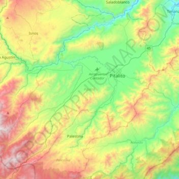
Name: Pitalito topographic map, elevation, terrain.
Location: Pitalito, Sur, Huila, RAP (Especial) Central, 417030, Colombia (1.65724 -76.32189 1.97668 -75.96183)
Average elevation: 1,635 m
Minimum elevation: 969 m
Maximum elevation: 2,762 m
Thank you for supporting this site ❤️
Make a donation
Make a donation