
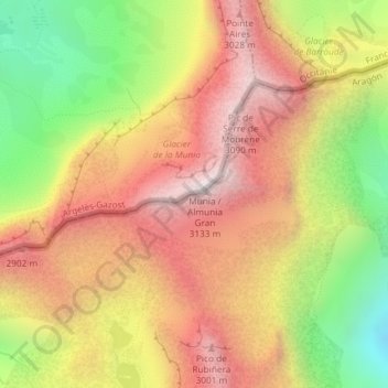
Pic de la Munia topographic map
Interactive map
Click on the map to display elevation.
About this map
Name: Pic de la Munia topographic map, elevation, terrain.
Location: Pic de la Munia, Bielsa, Sobrarbe, Huesca, Aragon, Espagne (42.71465 0.13090 42.71475 0.13100)
Average elevation: 2,560 m
Minimum elevation: 1,869 m
Maximum elevation: 3,115 m
Other topographic maps
Click on a map to view its topography, its elevation and its terrain.
Punta el Temblar
Punta el Temblar, Bielsa, Sobrarbe, Huesca, Aragon, 22365, Espagne
Average elevation: 1,912 m
Refugio de Pineta
Refugio de Pineta, valle de Pineta, Bielsa, Sobrarbe, Huesca, Aragon, Espagne
Average elevation: 1,567 m
Cylindre du Marboré
Cylindre du Marboré, Bielsa, Sobrarbe, Huesca, Aragon, Espagne
Average elevation: 2,847 m
Grand Astazou
Grand Astazou, Bielsa, Sobrarbe, Huesca, Aragon, Espagne
Average elevation: 2,558 m
Mont Perdu
Mont Perdu, Bielsa, Sobrarbe, Huesca, Aragon, Espagne
Average elevation: 2,807 m