
León XIII topographic map
Interactive map
Click on the map to display elevation.
About this map
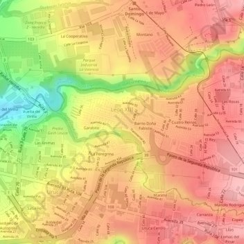
Name: León XIII topographic map, elevation, terrain.
Location: León XIII, Cantón Tibás, Provincia San José, 11304, Costa Rica (9.95490 -84.10703 9.96310 -84.09423)
Average elevation: 1,101 m
Minimum elevation: 1,000 m
Maximum elevation: 1,148 m
Other topographic maps
Click on a map to view its topography, its elevation and its terrain.
Río Virilla
Costa Rica > Provincia San José > León XIII
Río Virilla, León XIII, Cantón Tibás, Provincia San José, 11304, Costa Rica
Average elevation: 1,090 m