
Thank you for supporting this site ❤️
Make a donation
Make a donation
Lansing topographic map
Click on the map to display elevation.
Thank you for supporting this site ❤️
Make a donation
Make a donation
Lansing
Lansing is a popular destination among retirees and tourists from Florida, as well as those from the lower elevations of the Carolinas and Georgia.
Thank you for supporting this site ❤️
Make a donation
Make a donation
About this map
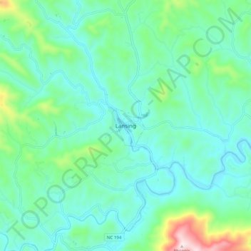
Name: Lansing topographic map, elevation, terrain.
Location: Lansing, Ashe County, North Carolina, 28643, United States (36.45939 -81.55099 36.53939 -81.47099)
Average elevation: 917 m
Minimum elevation: 791 m
Maximum elevation: 1,411 m
Thank you for supporting this site ❤️
Make a donation
Make a donation
Other topographic maps
Click on a map to view its topography, its elevation and its terrain.