
Thank you for supporting this site ❤️
Make a donation
Make a donation
Sakha Republic topographic map
Click on the map to display elevation.
Thank you for supporting this site ❤️
Make a donation
Make a donation
About this map
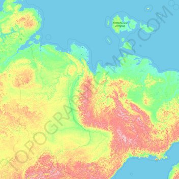
Name: Sakha Republic topographic map, elevation, terrain.
Location: Sakha Republic, Far Eastern Federal District, Russia (55.48767 105.50834 77.31023 163.10598)
Average elevation: 281 m
Minimum elevation: -3 m
Maximum elevation: 2,737 m
Thank you for supporting this site ❤️
Make a donation
Make a donation
Other topographic maps
Click on a map to view its topography, its elevation and its terrain.
Thank you for supporting this site ❤️
Make a donation
Make a donation
Тагил
Russia > Sverdlovsk Oblast > городской округ Нижний Тагил > Nizhny Tagil
Average elevation: 203 m
Thank you for supporting this site ❤️
Make a donation
Make a donation
Thank you for supporting this site ❤️
Make a donation
Make a donation
Thank you for supporting this site ❤️
Make a donation
Make a donation
Thank you for supporting this site ❤️
Make a donation
Make a donation
Thank you for supporting this site ❤️
Make a donation
Make a donation
Thank you for supporting this site ❤️
Make a donation
Make a donation