
Biri topographic map
Click on the map to display elevation.
About this map
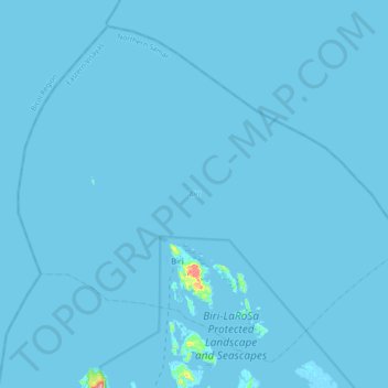
Name: Biri topographic map, elevation, terrain.
Location: Biri, Northern Samar, Eastern Visayas, Philippines (12.58855 124.21308 12.89445 124.57507)
Average elevation: 1 m
Minimum elevation: -3 m
Maximum elevation: 147 m
Other topographic maps
Click on a map to view its topography, its elevation and its terrain.
Catubig
Another tale was mentioned that the name Catubig was also a product of a 'word compact' between Americans and Filipinos. It was stated that an American surveyors saw a cat sunbathing by rolling along the grassy edge of the brook. They then approached a young lady who was doing her laundry and asked, “What is…
Average elevation: 41 m