
Quezon Memorial Circle topographic map
Interactive map
Click on the map to display elevation.
About this map
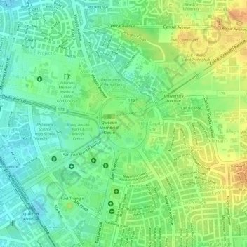
Name: Quezon Memorial Circle topographic map, elevation, terrain.
Average elevation: 49 m
Minimum elevation: 32 m
Maximum elevation: 68 m
Other topographic maps
Click on a map to view its topography, its elevation and its terrain.
Doña Imelda
Doña Imelda, Galas, 4th District, Quezon City, Eastern Manila District, Metro Manila, 1113, Philippines
Average elevation: 13 m
Don Manuel
Don Manuel, Galas, 4th District, Quezon City, Eastern Manila District, Metro Manila, 1113, Philippines
Average elevation: 11 m
Bagbag
Bagbag, 5th District, Quezon City, Eastern Manila District, Metro Manila, 1116, Philippines
Average elevation: 41 m
Tandang Sora
Tandang Sora, 6th District, Quezon City, Eastern Manila District, Metro Manila, 1116, Philippines
Average elevation: 39 m
Bahay Toro
Bahay Toro, Project 8, 1st District, Quezon City, Eastern Manila District, Metro Manila, 1106, Philippines
Average elevation: 30 m
Escopa III
Escopa III, Project 4, 3rd District, Quezon City, Eastern Manila District, Metro Manila, 1109, Philippines
Average elevation: 39 m
Valencia
Valencia, New Manila, 4th District, Quezon City, Eastern Manila District, Metro Manila, 1100, Philippines
Average elevation: 25 m
Nagkaisang Nayon
Nagkaisang Nayon, 5th District, Quezon City, Eastern Manila District, Metro Manila, 1125, Philippines
Average elevation: 41 m
White Plains
White Plains, 3rd District, Quezon City, Eastern Manila District, Metro Manila, 1110, Philippines
Average elevation: 34 m
Silangan
Silangan, Cubao, 3rd District, Quezon City, Eastern Manila District, Metro Manila, 1102, Philippines
Average elevation: 48 m
Pansol
Pansol, 3rd District, Quezon City, Eastern Manila District, Metro Manila, 1108, Philippines
Average elevation: 49 m
Greater Lagro
Greater Lagro, 5th District, Quezon City, Eastern Manila District, Metro Manila, 1118, Philippines
Average elevation: 69 m
Sunken Garden
Sunken Garden, UP Campus, Diliman, Quezon City, Eastern Manila District, Metro Manila, 1101, Philippines
Average elevation: 62 m
Laging Handa
Laging Handa, Scout Area, Quezon City, Metro Manila, 1103, Philippines
Average elevation: 29 m
Balintawak
Balintawak, Quezon City, Eastern Manila District, Metro Manila, 1106, Philippines
Average elevation: 22 m
Sauyo
Sauyo, 6th District, Quezon City, Eastern Manila District, Metro Manila, 1116, Philippines
Average elevation: 42 m
Apolonio Samson
Apolonio Samson, Balintawak, 6th District, Quezon City, Eastern Manila District, Metro Manila, 1106, Philippines
Average elevation: 22 m
Quezon Memorial Circle
Quezon Memorial Circle, Central, Diliman, 4th District, Quezon City, Second District, Metro Manila, 1100, Philippines
Average elevation: 49 m
Bago Bantay
Bago Bantay, 1st District, Quezon City, Eastern Manila District, Metro Manila, 1100, Philippines
Average elevation: 32 m
Novaliches Proper
Novaliches Proper, 5th District, Quezon City, Eastern Manila District, Metro Manila, 1123, Philippines
Average elevation: 46 m
San Antonio
San Antonio, San Francisco Del Monte, 1st District, Quezon City, Eastern Manila District, Metro Manila, 1105, Philippines
Average elevation: 23 m
Project 4
Project 4, 3rd District, Quezon City, Eastern Manila District, Metro Manila, 1100, Philippines
Average elevation: 41 m
Payatas
Payatas, 2nd District, Quezon City, Eastern Manila District, Metro Manila, 1100, Philippines
Average elevation: 63 m
Cubao
Cubao, Quezon City, Metro Manila, 1100, Philippines
Average elevation: 42 m
South Triangle
South Triangle, Scout Area, 4th District, Quezon City, Eastern Manila District, Metro Manila, 1103, Philippines
Average elevation: 36 m
Project 3
Project 3, 3rd District, Quezon City, Eastern Manila District, Metro Manila, 1100, Philippines
Average elevation: 48 m
2nd District
2nd District, Quezon City, Eastern Manila District, Metro Manila, 1100, Philippines
Average elevation: 55 m
Talipapa
Talipapa, Quezon City, 6th District, Second District, Metro Manila, 1116, Philippines
Average elevation: 34 m
La Mesa Eco Park
La Mesa Eco Park, Novaliches Reservoir, 5th District, Quezon City, Eastern Manila District, Metro Manila, 1118, Philippines
Average elevation: 66 m
Fairview
Fairview, 5th District, Quezon City, Eastern Manila District, Metro Manila, 1100, Philippines
Average elevation: 66 m
Commonwealth
Commonwealth, 2nd District, Quezon City, Metro Manila, Philippines
Average elevation: 72 m
Phil-Am
Phil-Am, 1st District, Quezon City, Eastern Manila District, Metro Manila, 1104, Philippines
Average elevation: 34 m
Balingasa
Balingasa, 1st District, Quezon City, Eastern Manila District, Metro Manila, Philippines
Average elevation: 20 m
Batasan Hills
Batasan Hills, Quezon City, Metro Manila, 1100, Philippines
Average elevation: 49 m
Kaligayahan
Kaligayahan, 5th District, Quezon City, Eastern Manila District, Metro Manila, 1124, Philippines
Average elevation: 68 m
Bagong Silangan
Bagong Silangan, 2nd District, Quezon City, Eastern Manila District, Metro Manila, Philippines
Average elevation: 49 m
Gulod
Gulod, 5th District, Quezon City, Eastern Manila District, Metro Manila, 1117, Philippines
Average elevation: 43 m
Matandang Balara
Matandang Balara, 3rd District, Quezon City, Eastern Manila District, Metro Manila, 1119, Philippines
Average elevation: 56 m