
Cromwell Community topographic map
Interactive map
Click on the map to display elevation.
About this map
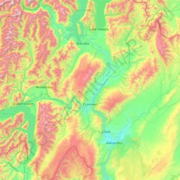
Name: Cromwell Community topographic map, elevation, terrain.
Average elevation: 876 m
Minimum elevation: 133 m
Maximum elevation: 2,593 m
Central Otago District trails, hiking, mountain biking, running and outdoor activities
Other topographic maps
Click on a map to view its topography, its elevation and its terrain.
Ranfurly
New Zealand > Otago > Central Otago District
Ranfurly is a town in the Central Otago District of Otago, New Zealand. Located 110 kilometres (68 miles) north of Dunedin, it lies in the dry rough plain of Maniototo at a moderately high altitude (around 430 metres or 1,410 feet above sea level) close to a small tributary of the Taieri River. It operates as…
Average elevation: 428 m
Ettrick
New Zealand > Otago > Central Otago District > Teviot Valley Community
Average elevation: 105 m
Mount Kāmaka
New Zealand > Otago > Central Otago District > Cromwell Community
Average elevation: 905 m
Clyde Dam
New Zealand > Otago > Central Otago District > Vincent Community > Clyde
Average elevation: 318 m
Bannockburn
New Zealand > Otago > Central Otago District > Cromwell Community
Average elevation: 279 m
Central Otago
New Zealand > Otago > Central Otago District > Vincent Community
Average elevation: 935 m
Roxburgh
New Zealand > Otago > Central Otago District > Teviot Valley Community
Average elevation: 223 m
Cromwell
New Zealand > Otago > Central Otago District > Cromwell Community > Cromwell
Average elevation: 330 m