
Thank you for supporting this site ❤️
Make a donation
Make a donation
Tuai topographic map
Click on the map to display elevation.
Thank you for supporting this site ❤️
Make a donation
Make a donation
About this map
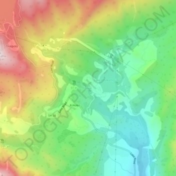
Name: Tuai topographic map, elevation, terrain.
Location: Tuai, Wairoa District, Hawke's Bay, New Zealand (-38.83270 177.12481 -38.79270 177.16481)
Average elevation: 378 m
Minimum elevation: 151 m
Maximum elevation: 725 m
Thank you for supporting this site ❤️
Make a donation
Make a donation
Other topographic maps
Click on a map to view its topography, its elevation and its terrain.
Lake Waikareiti
New Zealand > Hawke's Bay > Wairoa District
Its formation followed a landslide 18,000 years ago, in which a part of the landmass of 10 kilometers wide slid to the north-west. It is four kilometres to the northeast of the larger Lake Waikaremoana, into which it drains via the Aniwaniwa Stream. The smaller lake's surface is at an altitude of 880 metres…
Average elevation: 921 m
Thank you for supporting this site ❤️
Make a donation
Make a donation