
West topographic map
Interactive map
Click on the map to display elevation.
About this map
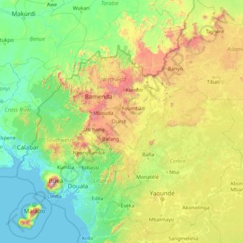
Name: West topographic map, elevation, terrain.
Location: West, Cameroon (2.92112 8.05287 8.12112 13.25287)
Average elevation: 529 m
Minimum elevation: -1 m
Maximum elevation: 3,977 m
Other topographic maps
Click on a map to view its topography, its elevation and its terrain.
Far-North
These rivers all follow a tropical regime, fluctuating between high water in the wet season (May to September) and low water in the dry season (October to April). At the height of the dry season, many of the waterways disappear completely or else diminish to a mere trickle. The Logone all but disappears during…
Average elevation: 357 m
South
The South Region begins at sea level on the coast. The land slowly climbs throughout the Kribi-Douala basin, which averages 300–600 metres in altitude, until it reaches the South Cameroon Plateau with elevations of 500 to 1000 metres above sea level. Rocky promontories on the coast and rolling, tree-covered…
Average elevation: 498 m