
Brantôme topographic map
Interactive map
Click on the map to display elevation.
About this map
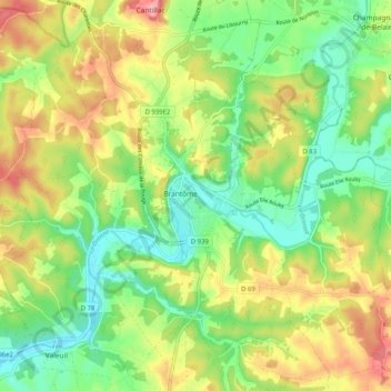
Name: Brantôme topographic map, elevation, terrain.
Average elevation: 145 m
Minimum elevation: 92 m
Maximum elevation: 219 m
Other topographic maps
Click on a map to view its topography, its elevation and its terrain.
Le Boulou
France > Nouvelle-Aquitaine > Brantôme en Périgord
Le Boulou, Saint-Crépin-de-Richemont, Brantôme en Périgord, Nontron, Dordogne, Nouvelle-Aquitaine, France métropolitaine, France
Average elevation: 163 m