
Argaud topographic map
Interactive map
Click on the map to display elevation.
About this map
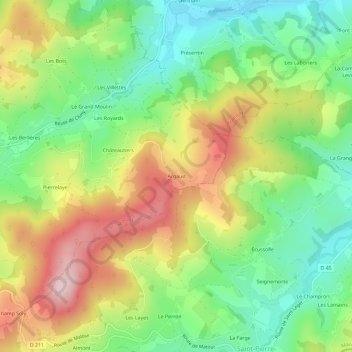
Name: Argaud topographic map, elevation, terrain.
Average elevation: 444 m
Minimum elevation: 306 m
Maximum elevation: 634 m
Other topographic maps
Click on a map to view its topography, its elevation and its terrain.
Le Bief
France > Bourgogne-Franche-Comté > Saône-et-Loire > Matour
Le Bief, Matour, Mâcon, Saône-et-Loire, Bourgogne-Franche-Comté, France métropolitaine, 71520, France
Average elevation: 500 m
Le Potet
France > Bourgogne-Franche-Comté > Saône-et-Loire > Matour > Le Potet
Le Potet, Matour, Mâcon, Saône-et-Loire, Bourgogne-Franche-Comté, France métropolitaine, 71520, France
Average elevation: 534 m
Croix de Mission
France > Bourgogne-Franche-Comté > Saône-et-Loire > Matour
Croix de Mission, Matour, Mâcon, Saône-et-Loire, Bourgogne-Franche-Comté, France métropolitaine, 71520, France
Average elevation: 501 m
La Baize
France > Bourgogne-Franche-Comté > Saône-et-Loire > Matour > Le Bief
La Baize, Le Bief, Matour, Mâcon, Saône-et-Loire, Bourgogne-Franche-Comté, France métropolitaine, 71520, France
Average elevation: 471 m