
Chames topographic map
Interactive map
Click on the map to display elevation.
About this map
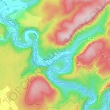
Name: Chames topographic map, elevation, terrain.
Average elevation: 237 m
Minimum elevation: 63 m
Maximum elevation: 427 m
Other topographic maps
Click on a map to view its topography, its elevation and its terrain.
Le Pont d'Arc
Frankrijk > Auvergne-Rhône-Alpes > Ardèche > Vallon-Pont-d'Arc > Chames
Le Pont d'Arc, Route des Gorges, Chames, Vallon-Pont-d'Arc, Largentière, Ardèche, Auvergne-Rhône-Alpes, Metropolitaans Frankrijk, 07150, Frankrijk
Average elevation: 208 m