
Make a donation
At Ta'if topographic map
Click on the map to display elevation.
Make a donation
At Ta'if
Taif (Arabic: اَلطَّائِفُ, romanized: aṭ-Ṭāʾif, lit. 'The circulated or encircled', Hejazi Arabic pronunciation: [atˤˈ tˤaː(j)ɪf]) is a city and governorate in the Mecca Province of Saudi Arabia. Located at an elevation of 1,879 m (6,165 ft) in the slopes of the Hijaz Mountains, which themselves are part of the Sarat Mountains, the city has a 2020 estimated population of 688,693 people, making it the 6th most populous city in the kingdom.
Make a donation
About this map
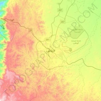
Name: At Ta'if topographic map, elevation, terrain.
Location: At Ta'if, Al Taif, Makkah Region, 26511, Saudi Arabia (21.11028 40.25583 21.43028 40.57583)
Average elevation: 1,742 m
Minimum elevation: 1,010 m
Maximum elevation: 2,595 m
Make a donation
Other topographic maps
Click on a map to view its topography, its elevation and its terrain.
Makkah Al Mukarramah
Mecca is located in the Hejaz region, a 200 km (124 mi) wide strip of mountains separating the Nafud desert from the Red Sea. The city is situated in a valley with the same name around 70 km (44 mi) west of the port city of Jeddah. Mecca is one of the lowest cities in elevation in the Hejaz region, located at…
Average elevation: 479 m
Make a donation
Make a donation
Make a donation
Rabigh
Rabigh (Arabic: رَابِغ, romanized: Rābigh) is a city and governorate in the Province of Makkah of the Kingdom of Saudi Arabia, situated on the coast of the Red Sea, around 208 km (129 miles) northwest of Mecca in the historic Hejazi region. The city had an estimated population of 180,352 in 2014 and is…
Average elevation: 145 m
Make a donation
Make a donation
Makkah Al Mukarramah
Mecca is located in the Hejaz region, a 200 km (124 mi) wide strip of mountains separating the Nafud desert from the Red Sea. The city is situated in a valley with the same name around 70 km (44 mi) east of the port city of Jeddah. Mecca is one of the lowest cities in elevation in the Hejaz region, located at…
Average elevation: 479 m
Make a donation
Rabigh
Rabigh (Arabic: رَابِغ, romanized: Rābigh) is a city and governorate in the Province of Makkah of the Kingdom of Saudi Arabia, situated on the coast of the Red Sea, around 208 km (129 mi) northwest of Mecca in the historic Hejazi region. The city had an estimated population of 180,352 in 2014 and is…
Average elevation: 145 m
Makkah Al Mukarramah
Mecca is located in the Hejaz region, a 200 km (124 mi) wide strip of mountains separating the Nafud desert from the Red Sea. The city is situated in a valley with the same name around 70 km (44 mi) east of the port city of Jeddah. Mecca is one of the lowest cities in elevation in the Hejaz region, located at…
Average elevation: 479 m
Make a donation
Make a donation
Makkah Al Mukarramah
Mecca is located in the Hejaz region, a 200 km (124 mi) wide strip of mountains separating the Nafud desert from the Red Sea. The city is situated in a valley with the same name around 70 km (44 mi) west of the port city of Jeddah. Mecca is one of the lowest cities in elevation in the Hejaz region, located at…
Average elevation: 479 m
Makkah Al Mukarramah
Mecca is located in the Hejaz region, a 200 km (124 mi) wide strip of mountains separating the Nafud desert from the Red Sea. The city is situated in a valley with the same name around 70 km (44 mi) east of the port city of Jeddah. Mecca is one of the lowest cities in elevation in the Hejaz region, located at…
Average elevation: 479 m
Makkah Al Mukarramah
Mecca is located in the Hejaz region, a 200 km (124 mi) wide strip of mountains separating the Nafud desert from the Red Sea. The city is situated in a valley with the same name around 70 km (44 mi) west of the port city of Jeddah. Mecca is one of the lowest cities in elevation in the Hejaz region, located at…
Average elevation: 479 m
Make a donation
Makkah Al Mukarramah
Mecca is located in the Hejaz region, a 200 km (124 mi) wide strip of mountains separating the Nafud desert from the Red Sea. The city is situated in a valley with the same name around 70 km (44 mi) west of the port city of Jeddah. Mecca is one of the lowest cities in elevation in the Hejaz region, located at…
Average elevation: 479 m
Rabigh
Rabigh (Arabic: رَابِغ, romanized: Rābigh) is a city and governorate in the Province of Makkah of the Kingdom of Saudi Arabia, situated on the coast of the Red Sea, around 208 km (129 mi) northwest of Mecca in the historic Hejazi region. The city had an estimated population of 180,352 in 2014 and is…
Average elevation: 145 m
Makkah Al Mukarramah
Mecca is located in the Hejaz region, a 200 km (124 mi) wide strip of mountains separating the Nafud desert from the Red Sea. The city is situated in a valley with the same name around 70 km (44 mi) west of the port city of Jeddah. Mecca is one of the lowest cities in elevation in the Hejaz region, located at…
Average elevation: 479 m