
Thank you for supporting this site ❤️
Make a donation
Make a donation
Kujalleq topographic map
Click on the map to display elevation.
Thank you for supporting this site ❤️
Make a donation
Make a donation
About this map
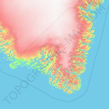
Name: Kujalleq topographic map, elevation, terrain.
Location: Kujalleq, Greenland (59.51539 -49.03148 62.75806 -41.25332)
Average elevation: 784 m
Minimum elevation: -5 m
Maximum elevation: 2,854 m
Thank you for supporting this site ❤️
Make a donation
Make a donation
Other topographic maps
Click on a map to view its topography, its elevation and its terrain.
Nuuk
Nuuk's sports clubs include Nuuk IL (established in 1934), B-67, and GSS Nuuk. Nuuk Stadium is a multi-purpose stadium, used mostly for football games. The stadium has a capacity of 2,000.[67] The stadium can also be used as an entertainment venue: the Scottish rock band Nazareth performed at the venue. Nuuk…
Average elevation: 76 m