
Thank you for supporting this site ❤️
Make a donation
Make a donation
Venture topographic map
Click on the map to display elevation.
Thank you for supporting this site ❤️
Make a donation
Make a donation
About this map
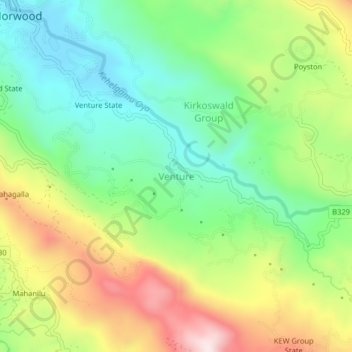
Name: Venture topographic map, elevation, terrain.
Location: Venture, Nuwara Eliya District, Central Province, Sri Lanka (6.80062 80.61042 6.84062 80.65042)
Average elevation: 1,311 m
Minimum elevation: 1,108 m
Maximum elevation: 1,630 m
Thank you for supporting this site ❤️
Make a donation
Make a donation
Other topographic maps
Click on a map to view its topography, its elevation and its terrain.