
Make a donation
Utakura River topographic map
Click on the map to display elevation.
Make a donation
About this map
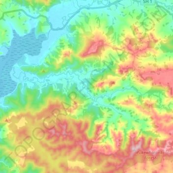
Name: Utakura River topographic map, elevation, terrain.
Average elevation: 124 m
Minimum elevation: -1 m
Maximum elevation: 337 m
Far North District trails, hiking, mountain biking, running and outdoor activities
Make a donation
Other topographic maps
Click on a map to view its topography, its elevation and its terrain.
Rangitoto
New Zealand > Northland > Far North District > Kaikohe-Hokianga Community
Average elevation: 24 m
Fern Hill
New Zealand > Northland > Far North District > Kaikohe-Hokianga Community
Average elevation: 122 m
Whirinaki
New Zealand > Northland > Far North District > Kaikohe-Hokianga Community
Average elevation: 71 m
Pukawa
New Zealand > Northland > Far North District > Kaikohe-Hokianga Community
Average elevation: 101 m
Make a donation
Waihou Valley
New Zealand > Northland > Far North District > Kaikohe-Hokianga Community
Average elevation: 86 m
Runaruna
New Zealand > Northland > Far North District > Kaikohe-Hokianga Community
Average elevation: 81 m
Rotokakahi
New Zealand > Northland > Far North District > Kaikohe-Hokianga Community
Average elevation: 90 m
Broadwood
New Zealand > Northland > Far North District > Kaikohe-Hokianga Community
Average elevation: 144 m
Make a donation
Tauwhare
New Zealand > Northland > Far North District > Kaikohe-Hokianga Community
Average elevation: 281 m