
Mexico City topographic map
Interactive map
Click on the map to display elevation.
Mexico City
Mexico City (Spanish: Ciudad de México, locally [sjuˈða(ð) ðe ˈmexiko] ; abbr.: CDMX; Nahuatl: Āltepētl Mēxihco, Nahuatl pronunciation: [aːl'tepeːt͡ɬ meːˈʃiʔko]; Otomi: 'Monda) is the capital and largest city of Mexico, and the most populous city in North America. Mexico City is one of the most important cultural and financial centers in the world. It is located in the Valley of Mexico within the high Mexican central plateau, at an altitude of 2,240 meters (7,350 ft). The city has 16 boroughs or demarcaciones territoriales, which are in turn divided into neighborhoods or colonias.
About this map
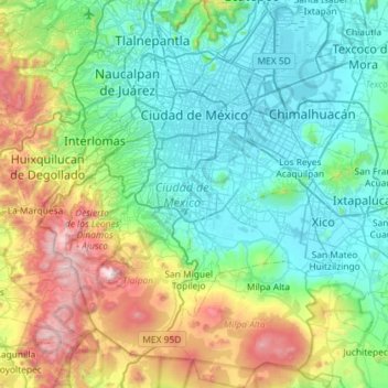
Name: Mexico City topographic map, elevation, terrain.
Location: Mexico City, Mexico (19.04872 -99.36492 19.59276 -98.94030)
Average elevation: 2,619 m
Minimum elevation: 2,223 m
Maximum elevation: 3,915 m
Other topographic maps
Click on a map to view its topography, its elevation and its terrain.
Sombrerete
Mexico > Zacatecas > Sombrerete
The region is between the Sierra Madre Occidental and the central highlands of Mexico. The municipality is in a valley is surrounded on all sides by small mountain ranges such as the Sierra de Sombrerete and the Sierra de Santa María with prominent elevations such as the Cerro Grande, Cerro Reyes, Cerro…
Average elevation: 2,401 m
Hermosillo
Mexico > Sonora > Hermosillo
The Cerro de la Campana mountain is one of the symbols of Hermosillo. Its summit is 350 metres (1,150 ft) above the valley floor and contains a lookout called El Caracol, which was inaugurated in 1909. There are two theories as to the origin of the mountain's name. One states that it is from a peculiar…
Average elevation: 248 m
Tecate
Mexico > Baja California > Municipio de Tecate
Tecate's altitude of approximately 540 m (1,770 ft) above sea level and its proximity to the ocean contribute to the temperate climate. It rains enough in the area (almost 360 mm [14 in] per year) for a thick ground cover of shrubs and scattered trees to grow.
Average elevation: 595 m
San Luis Potosí City
Mexico > San Luis Potosi > Municipio de San Luis Potosí
San Luis Potosí, commonly referred to as San Luis, or by its initials SLP (Otomi: Nmiñ'u), is the capital and the most populous city of the Mexican state of San Luis Potosí. It is the municipal seat of the surrounding municipality of San Luis Potosí. The city lies at an elevation of 1,864 metres (6,115…
Average elevation: 2,004 m
Morelia
Under the Köppen climate classification, Morelia has a subtropical highland climate (Cwb), with warm-to-hot days and cool nights year round due to its high elevation. Most precipitation falls during the summer rainy season. Average monthly temperatures are between 14 and 22 °C (57 and 72 °F), with maximum…
Average elevation: 2,071 m
San Antonio Texas
Mexico > Veracruz > Cosamaloapan de Carpio > San Antonio Texas
Average elevation: 19 m
Puerto Vallarta
Mexico > Jalisco > Puerto Vallarta
Fourth: In 1968 the Puerto Vallarta municipality was elevated to City status. The elevation in status reflected interest by Mexican federal and state governments in developing the Puerto Vallarta as an international resort destination. Puerto Vallarta has since also attracted a lively immigrant community from…
Average elevation: 306 m