
Maxillou topographic map
Interactive map
Click on the map to display elevation.
About this map
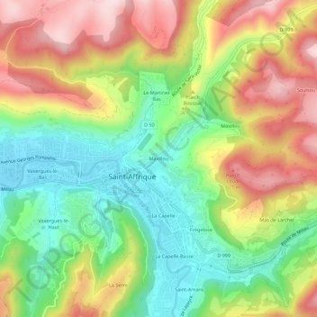
Name: Maxillou topographic map, elevation, terrain.
Average elevation: 470 m
Minimum elevation: 313 m
Maximum elevation: 661 m
Other topographic maps
Click on a map to view its topography, its elevation and its terrain.
Les Combes
France > Occitanie > Aveyron > Saint-Affrique
Les Combes, Saint-Affrique, Millau, Aveyron, Occitanie, France métropolitaine, 12400, France
Average elevation: 469 m
Vaxergues-le-Bas
France > Occitanie > Aveyron > Saint-Affrique
Vaxergues-le-Bas, Saint-Affrique, Millau, Aveyron, Occitanie, France métropolitaine, 12400, France
Average elevation: 442 m
Maxillou
France > Occitanie > Aveyron > Saint-Affrique
Maxillou, Saint-Affrique, Millau, Aveyron, Occitanie, France métropolitaine, 12400, France
Average elevation: 508 m
La Foux
France > Occitanie > Aveyron > Saint-Affrique
La Foux, Saint-Affrique, Millau, Aveyron, Occitanie, France métropolitaine, 12400, France
Average elevation: 567 m
La Capelle
France > Occitanie > Aveyron > Saint-Affrique
La Capelle, Saint-Affrique, Millau, Aveyron, Occitanie, France métropolitaine, 12400, France
Average elevation: 460 m