
Thank you for supporting this site ❤️
Make a donation
Make a donation
San Pedro Sula topographic map
Click on the map to display elevation.
Thank you for supporting this site ❤️
Make a donation
Make a donation
About this map
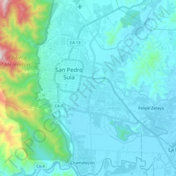
Name: San Pedro Sula topographic map, elevation, terrain.
Location: San Pedro Sula, La Lima, Cortés, Honduras (15.41773 -88.05515 15.56929 -87.91777)
Average elevation: 197 m
Minimum elevation: 25 m
Maximum elevation: 1,433 m
Thank you for supporting this site ❤️
Make a donation
Make a donation
Other topographic maps
Click on a map to view its topography, its elevation and its terrain.