
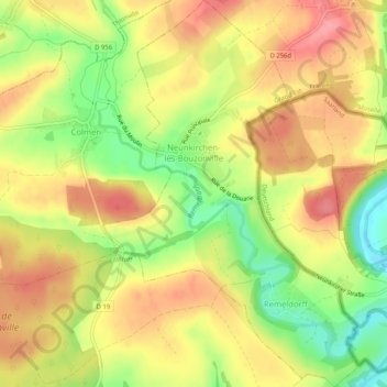
Neunkirchen-lès-Bouzonville topographic map
Interactive map
Click on the map to display elevation.
About this map
Name: Neunkirchen-lès-Bouzonville topographic map, elevation, terrain.
Average elevation: 236 m
Minimum elevation: 182 m
Maximum elevation: 276 m
Other topographic maps
Click on a map to view its topography, its elevation and its terrain.
Château-Salins
Château-Salins, Sarrebourg-Château-Salins, Moselle, Grand Est, Metropolitan France, 57170, France
Average elevation: 242 m
Sierck-les-Bains
Sierck-les-Bains, Thionville, Moselle, Grand Est, Metropolitan France, 57480, France
Average elevation: 239 m
Vic-sur-Seille
Vic-sur-Seille, Sarrebourg-Château-Salins, Moselle, Grand Est, Metropolitan France, 57630, France
Average elevation: 240 m
Kirsch-lès-Sierck
Kirsch-lès-Sierck, Thionville, Moselle, Grand Est, Metropolitan France, 57480, France
Average elevation: 297 m
Kédange-sur-Canner
Kédange-sur-Canner, Thionville, Moselle, Grand Est, Metropolitan France, 57920, France
Average elevation: 226 m
Hettange-Grande
Hettange-Grande, Thionville, Moselle, Grand Est, Metropolitan France, 57330, France
Average elevation: 207 m
Pierrevillers
Pierrevillers, Metz, Moselle, Grand Est, Metropolitan France, 57120, France
Average elevation: 270 m
Contz-les-Bains
Contz-les-Bains, Thionville, Moselle, Grand Est, Metropolitan France, 57480, France
Average elevation: 214 m
Cité Émile Huchet
France > Grand Est > Moselle > Saint-Avold
Cité Émile Huchet, Saint-Avold, Forbach-Boulay-Moselle, Moselle, Grand Est, Metropolitan France, 57500, France
Average elevation: 253 m
Berg-sur-Moselle
France > Grand Est > Moselle > Berg-sur-Moselle
Berg-sur-Moselle, Thionville, Moselle, Grand Est, Metropolitan France, 57570, France
Average elevation: 168 m
Saint-Avold
France > Grand Est > Moselle > Saint-Avold
Saint-Avold, Forbach-Boulay-Moselle, Moselle, Grand Est, Metropolitan France, 57500, France
Average elevation: 271 m
Everst Garten
France > Grand Est > Moselle > Villing > Trois Maisons
Everst Garten, Trois Maisons, Villing, Forbach-Boulay-Moselle, Moselle, Grand Est, Metropolitan France, 57550, France
Average elevation: 286 m
Porcelette
Porcelette, Forbach-Boulay-Moselle, Moselle, Grand Est, Metropolitan France, 57890, France
Average elevation: 257 m
Thionville
Thionville, Moselle, Grand Est, Metropolitan France, 57100, France
Average elevation: 190 m
Buhl-Lorraine
France > Grand Est > Moselle > Buhl-Lorraine
Buhl-Lorraine, Sarrebourg-Château-Salins, Moselle, Grand Est, Metropolitan France, 57400, France
Average elevation: 279 m