
Pellegrini Lake topographic map
Interactive map
Click on the map to display elevation.
About this map
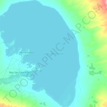
Name: Pellegrini Lake topographic map, elevation, terrain.
Average elevation: 287 m
Minimum elevation: 270 m
Maximum elevation: 414 m
After the first years of operation of the dam Dique Ing. Ballester, in 1936, the lake that was formed already registered a water level of 267,60 m. Up to this date, that level has small variations around the 272 m elevation.