
Portales topographic map
Interactive map
Click on the map to display elevation.
About this map
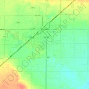
Name: Portales topographic map, elevation, terrain.
Average elevation: 1,226 m
Minimum elevation: 1,208 m
Maximum elevation: 1,254 m
Other topographic maps
Click on a map to view its topography, its elevation and its terrain.
Pep
United States > New Mexico > Roosevelt County
Pep, Roosevelt County, New Mexico, 88126, United States
Average elevation: 1,294 m
Dora
United States > New Mexico > Roosevelt County
Dora, Roosevelt County, New Mexico, United States
Average elevation: 1,310 m
Lingo
United States > New Mexico > Roosevelt County
Lingo, Roosevelt County, New Mexico, 88123, United States
Average elevation: 1,217 m
Arch
United States > New Mexico > Roosevelt County
Arch, Roosevelt County, New Mexico, United States
Average elevation: 1,198 m
Causey
United States > New Mexico > Roosevelt County
Causey, Roosevelt County, New Mexico, United States
Average elevation: 1,236 m