
Make a donation
Rio Grande topographic map
Click on the map to display elevation.
Make a donation
Rio Grande
Rio Grande, as the name suggests, is a littoral city, which boasts what many call the longest beach in the world — Praia do Cassino. This beach is approximately 250 km (160 mi) of uninterrupted Atlantic coastline. The entire municipality lies at a very low altitude — at its highest point only 10 meters (33 feet) above sea level. Additionally, the city, which is surrounded by water, sinks about one centimeter every year.
Make a donation
About this map
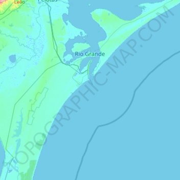
Name: Rio Grande topographic map, elevation, terrain.
Average elevation: 3 m
Minimum elevation: -3 m
Maximum elevation: 257 m
Make a donation
Other topographic maps
Click on a map to view its topography, its elevation and its terrain.
Pelotas
Brazil > Rio Grande do Sul > Aglomeração Urbana do Sul > Pelotas
As it is situated on a plain near the ocean, the urban area lies on a low elevation, being, on average, 7 meters (23 ft) above sea level. The interior of the municipality is on a plateau called Serras de Sudeste (Southeastern Mountain Ranges). Consequently, the altitude in Pelotas' rural area reaches 429…
Average elevation: 18 m