
Mézergues topographic map
Interactive map
Click on the map to display elevation.
About this map
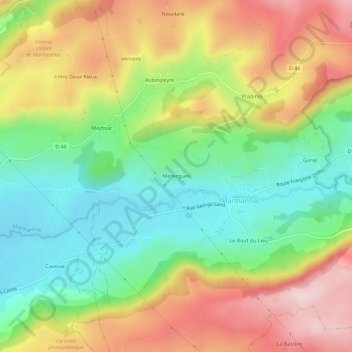
Name: Mézergues topographic map, elevation, terrain.
Average elevation: 778 m
Minimum elevation: 628 m
Maximum elevation: 971 m
Other topographic maps
Click on a map to view its topography, its elevation and its terrain.
1511806 - C
France > Auvergne-Rhône-Alpes > Cantal > Marmanhac
1511806 - C, Route des Crêtes, Lotissement de Conthe, Les Plots, Marmanhac, Aurillac, Cantal, Auvergne-Rhône-Alpes, France métropolitaine, France
Average elevation: 855 m