
Thank you for supporting this site ❤️
Make a donation
Make a donation
Grahamville topographic map
Click on the map to display elevation.
Thank you for supporting this site ❤️
Make a donation
Make a donation
About this map
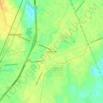
Name: Grahamville topographic map, elevation, terrain.
Average elevation: 16 m
Minimum elevation: -2 m
Maximum elevation: 27 m
Thank you for supporting this site ❤️
Make a donation
Make a donation
Other topographic maps
Click on a map to view its topography, its elevation and its terrain.
Hardeeville
United States > South Carolina > Jasper County
The city is located on the Atlantic coastal plain, with very few variations in elevation. The average elevation of the city is approximately 20 feet (6.1 m) above mean sea level. Most of Hardeeville is located within Jasper County, though a small portion of the city crosses into Beaufort County. Much of the…
Average elevation: 5 m