
Roma topographic map
Click on the map to display elevation.
Roma
Roma experiences a humid subtropical climate (Köppen: Cfa, Trewartha: Cfal); with hot summers with moderate rains; warm to hot, relatively dry springs and autumns; and mild, dry winters. Its location on the far south of the Carnarvon Range at an elevation of 299 metres above sea level means that it is cooler and wetter than the plains to the south and west, while being warmer and drier than areas to the north and east, and also receives enough precipitation to avoid being classified as a semi-arid climate.
About this map
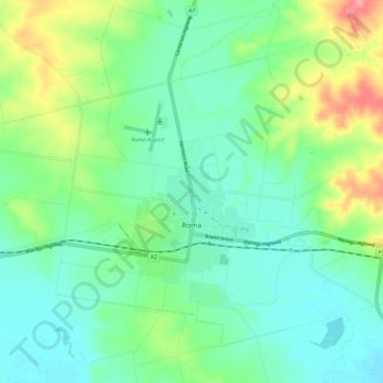
Name: Roma topographic map, elevation, terrain.
Location: Roma, Maranoa Regional, Queensland, 4455, Australia (-26.60440 148.74504 -26.51948 148.86276)
Average elevation: 315 m
Minimum elevation: 289 m
Maximum elevation: 377 m
Other topographic maps
Click on a map to view its topography, its elevation and its terrain.
Torres Strait
Several clusters of islands lie in the Strait, collectively called the Torres Strait Islands. There are at least 274 of these islands, of which 17 have present-day permanent settlements. These islands have a variety of topographies, ecosystems and formation history. Several of those closest to the New Guinea…
Average elevation: 0 m
Koala Park Bushland Conservation Reserve
Australia > Queensland > Sunshine Coast Regional > Nambour
Average elevation: 35 m