
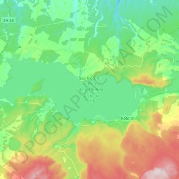
Lake Rotoiti / Te Roto kite ā Ihenga i ariki ai Kahu topographic map
Interactive map
Click on the map to display elevation.
Lake Rotoiti / Te Roto kite ā Ihenga i ariki ai Kahu topographic map, elevation, terrain
About this map
Name: Lake Rotoiti / Te Roto kite ā Ihenga i ariki ai Kahu topographic map, elevation, terrain.
Average elevation: 375 m
Minimum elevation: 177 m
Maximum elevation: 796 m
Routes: Rotorua Lakes District GPS tracks, routes, trails, hikes
Other topographic maps
Click on a map to view its topography, its elevation and its terrain.
Whangamarino
New Zealand > Bay of Plenty > Rotorua Lakes District > Okere Falls
Average elevation: 317 m