
Thank you for supporting this site ❤️
Make a donation
Make a donation
Roxas topographic map
Click on the map to display elevation.
Thank you for supporting this site ❤️
Make a donation
Make a donation
About this map
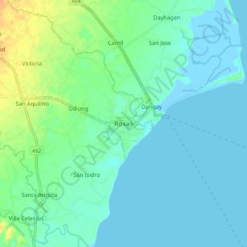
Name: Roxas topographic map, elevation, terrain.
Location: Roxas, Oriental Mindoro, Mimaropa, Philippines (12.55086 121.47702 12.63086 121.55702)
Average elevation: 7 m
Minimum elevation: -6 m
Maximum elevation: 30 m
Thank you for supporting this site ❤️
Make a donation
Make a donation
Other topographic maps
Click on a map to view its topography, its elevation and its terrain.