
Thank you for supporting this site ❤️
Make a donation
Make a donation
Richards Bay topographic map
Click on the map to display elevation.
Thank you for supporting this site ❤️
Make a donation
Make a donation
About this map
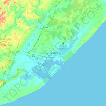
Name: Richards Bay topographic map, elevation, terrain.
Average elevation: 31 m
Minimum elevation: -1 m
Maximum elevation: 249 m
Thank you for supporting this site ❤️
Make a donation
Make a donation
Other topographic maps
Click on a map to view its topography, its elevation and its terrain.
uMhlathuze Local Municipality
South Africa > KwaZulu-Natal > King Cetswayo District Municipality
Average elevation: 51 m