
Make a donation
Lindis Pass topographic map
Click on the map to display elevation.
Make a donation
Lindis Pass
Lindis Pass (Māori: Ōmakō) (elevation 971 m) is located in the South Island of New Zealand. A carpark at the top of the pass provides access to a viewpoint and two short trails to other viewing spots.
Make a donation
About this map
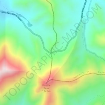
Name: Lindis Pass topographic map, elevation, terrain.
Location: Lindis Pass, Waitaki District, Canterbury, New Zealand (-44.58831 169.64303 -44.58821 169.64313)
Average elevation: 1,011 m
Minimum elevation: 806 m
Maximum elevation: 1,407 m
Waitaki District trails, hiking, mountain biking, running and outdoor activities
Make a donation
Other topographic maps
Click on a map to view its topography, its elevation and its terrain.
Lake Ōhau
New Zealand > Canterbury > Waitaki District
Wilding Pines (Pinus Cortorta, Pinus sylvestris) are problematic on the foreshore of Lake Ōhau. Pinus contorta grow “probably five to 10 times faster” in the Mackenzie Country (and Lake Ōhau) than in their native North America. They can establish themselves at altitudes of up to 2000 metres. Where they…
Average elevation: 904 m