
Ban Khlong Khraitai topographic map
Interactive map
Click on the map to display elevation.
About this map
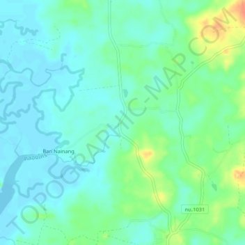
Name: Ban Khlong Khraitai topographic map, elevation, terrain.
Location: Ban Khlong Khraitai, Krabi Province, Thailand (8.22855 98.73778 8.26855 98.77778)
Average elevation: 13 m
Minimum elevation: -1 m
Maximum elevation: 46 m
Other topographic maps
Click on a map to view its topography, its elevation and its terrain.
Ko Phi Phi Leh
Ko Phi Phi Leh, Krabi Province, Thailand
Average elevation: 11 m
Ao Luboa
Thailand > Krabi Province > Ao Luboa
Ao Luboa, Krabi Province, Thailand
Average elevation: 34 m
Laem Pho
Thailand > Krabi Province > Haad Yao
Laem Pho, Haad Yao, Krabi Province, Thailand
Average elevation: 8 m