
Krishna topographic map
Interactive map
Click on the map to display elevation.
About this map
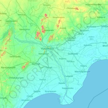
Name: Krishna topographic map, elevation, terrain.
Location: Krishna, Andhra Pradesh, India (15.71226 79.99173 17.13822 81.57061)
Average elevation: 42 m
Minimum elevation: -2 m
Maximum elevation: 526 m
Other topographic maps
Click on a map to view its topography, its elevation and its terrain.
Mandli
India > Andhra Pradesh > Somandepalle
Mandli, Somandepalle, Sri Sathya Sai, Andhra Pradesh, India
Average elevation: 608 m
Ramanda
India > Andhra Pradesh > Peda Bayalu > Ramanda
Ramanda, Peda Bayalu, Visakhapatnam, Andhra Pradesh, India
Average elevation: 1,051 m