
Chengdu topographic map
Interactive map
Click on the map to display elevation.
About this map
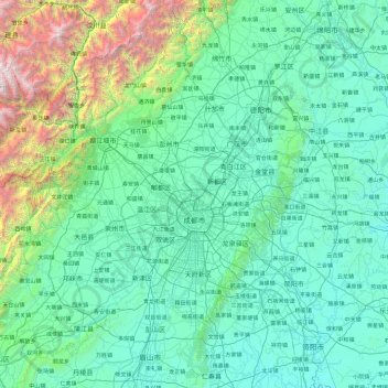
Name: Chengdu topographic map, elevation, terrain.
Location: Chengdu, Sichuan, China (30.09155 102.98962 31.43710 104.89485)
Average elevation: 913 m
Minimum elevation: 330 m
Maximum elevation: 5,323 m
Other topographic maps
Click on a map to view its topography, its elevation and its terrain.
Quge River
Quge River, Chaluo, Batang County, Garzê Tibetan Autonomous Prefecture, Sichuan, China
Average elevation: 4,159 m