
Thank you for supporting this site ❤️
Make a donation
Make a donation
Days Bay topographic map
Click on the map to display elevation.
Thank you for supporting this site ❤️
Make a donation
Make a donation
About this map
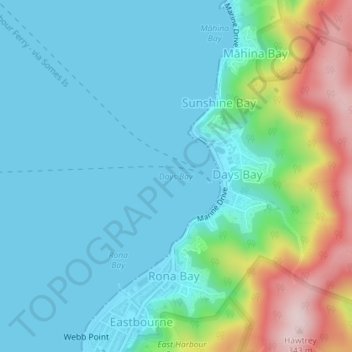
Name: Days Bay topographic map, elevation, terrain.
Location: Days Bay, Lower Hutt, Wellington, 5013, New Zealand (-41.28022 174.90189 -41.28012 174.90199)
Average elevation: 74 m
Minimum elevation: 0 m
Maximum elevation: 331 m
Wellington trails, hiking, mountain biking, running and outdoor activities
Thank you for supporting this site ❤️
Make a donation
Make a donation