
Make a donation
Berlin topographic map
Click on the map to display elevation.
Make a donation
Berlin
Berlin straddles the banks of the Spree, which flows into the Havel (a tributary of the Elbe) in the western borough of Spandau. Among the city's main topographical features are the many lakes in the western and southeastern boroughs formed by the Spree, Havel and Dahme, the largest of which is Lake Müggelsee. Due to its location in the European Plain, Berlin is influenced by a temperate seasonal climate. About one-third of the city's area is composed of forests, parks, gardens, rivers, canals, and lakes. The city lies in the Central German dialect area, the Berlin dialect being a variant of the Lusatian-New Marchian dialects.
Make a donation
About this map
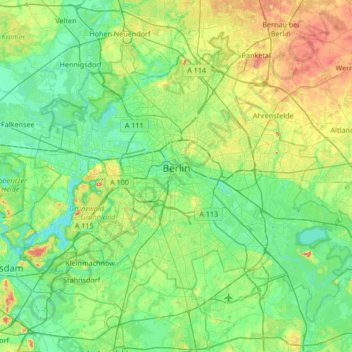
Name: Berlin topographic map, elevation, terrain.
Location: Berlin, Germany (52.33824 13.08835 52.67551 13.76116)
Average elevation: 48 m
Minimum elevation: 26 m
Maximum elevation: 112 m
Make a donation
Other topographic maps
Click on a map to view its topography, its elevation and its terrain.
Berlin
Berlin straddles the banks of the River Spree, which flows into the River Havel (a tributary of the River Elbe) in the western borough of Spandau. Among the city's main topographical features are the many lakes in the western and southeastern boroughs formed by the Spree, Havel, and Dahme rivers (the largest…
Average elevation: 47 m
Stuttgart
Germany > Baden-Württemberg > Stuttgart
Stuttgart covers an area of 207.35 km2 (80 sq mi) and sits at elevation ranging from 207 m (679 ft) above sea level by the Neckar river to 549 m (1,801 ft) on Bernhartshöhe hill – something rather unique in large German cities. The most prominent elevated locales in Stuttgart are the Birkenkopf (511 m…
Average elevation: 353 m
Hamburg
The neighborhoods of Neuenfelde, Cranz, Francop and Finkenwerder are part of the Altes Land (old land) region, the largest contiguous fruit-producing region in Central Europe. Neugraben-Fischbek has Hamburg's highest elevation, the Hasselbrack at 116.2 metres (381 ft) AMSL. Hamburg borders the states of…
Average elevation: 23 m
Hamburg
The neighborhoods of Neuenfelde, Cranz, Francop and Finkenwerder are part of the Altes Land (old land) region, the largest contiguous fruit-producing region in Central Europe. Neugraben-Fischbek has Hamburg's highest elevation, the Hasselbrack at 116.2 metres (381 ft) AMSL. Hamburg borders the states of…
Average elevation: 56 m
Make a donation
Blockhaus
Germany > North Rhine-Westphalia > Oberbergischer Kreis > Reichshof > Windfus
Average elevation: 409 m
Make a donation
Wuppertal
Germany > North Rhine-Westphalia > Wuppertal
Uniquely for Germany, it is a "linear city", owing to the steep hillsides along the river Wupper. Its highest hill is the Lichtscheid, which is 351 metres above sea level. The dominant urban centres Elberfeld (historic commercial centre) and Barmen (more industrial) have formed a continuous urbanized area…
Average elevation: 209 m
Sythen
Germany > North Rhine-Westphalia > Kreis Recklinghausen > Haltern am See
Average elevation: 54 m
Make a donation
Aletsberg
Germany > Bavaria > Landkreis Deggendorf > Deggendorf > Oberkandelbach
Average elevation: 347 m
Neu-Grambow
Germany > Mecklenburg-Vorpommern > Vorpommern-Greifswald > Grambow
Average elevation: 38 m
Make a donation
Make a donation
Zugspitze
Germany > Bavaria > Landkreis Garmisch-Partenkirchen > Grainau
The mountain rises eleven kilometres southwest of Garmisch-Partenkirchen and just under six kilometres east of Ehrwald. The border between Germany and Austria runs over the west summit; thus the Zugspitze massif belongs to the German state of Bavaria and the Austrian state of Tyrol. The municipalities…
Average elevation: 2,300 m
Bochum
Germany > North Rhine-Westphalia > Bochum
The city lies on the low rolling hills of Bochum land ridge (Bochumer Landrücken), part of the Ruhrhöhen (highest elevations) between the Ruhr and Emscher rivers at the border of the southern and northern Ruhr coal region. The highest point of the city is at Kemnader Straße (Kemnader Street) in Stiepel at…
Average elevation: 107 m
Make a donation
Michelau i.Steigerwald
Germany > Bavaria > Landkreis Schweinfurt > Michelau i.Steigerwald
Average elevation: 333 m
Make a donation
Ore Mountains
The higher altitudes from around 500 m above sea level on the German side belong to the Ore Mountains/Vogtland Nature Park – the largest of its kind in Germany with a length of 120 km. The eastern Ore Mountains are protected landscape. Other smaller areas on the German and Czech sides are protected as nature…
Average elevation: 443 m
Erlangen
In 1435 the church, which had been the daughter church of St. Martin in Forchheim up until this point, was elevated to its own parish. The main task of the Erlangen priest was the pastoral care in the city of Erlangen and the St. Martin's Chapel on the Martinsbühl, which was now named for the first time.…
Average elevation: 331 m
Make a donation
Neuschwanstein Castle
Germany > Bavaria > Landkreis Ostallgäu > Hohenschwangau
The municipality of Schwangau lies at an elevation of 800 m (2,620 ft) at the southwest border of the German state of Bavaria. Its surroundings are characterised by the transition between the Alpine foothills in the south (toward the nearby Austrian border) and a hilly landscape in the north that appears flat…
Average elevation: 982 m
Eifel
Germany > Rhineland-Palatinate > Landkreis Ahrweiler > Adenau
The Eifel is in the Atlantic climate zone with its relatively high precipitation; winters that are moderately cold and long with periods of snow; and summers that are often humid and cool. The prevailing wind is west/southwest. A relatively dry and milder climate prevails in the wind and rain shadow of the…
Average elevation: 585 m
Make a donation
Hau
Germany > North Rhine-Westphalia > Rheinisch-Bergischer Kreis > Kürten > Waldmühle
Average elevation: 229 m
Immenstadt im Allgäu
Germany > Bavaria > Landkreis Oberallgäu > Immenstadt im Allgäu
Average elevation: 910 m
Potsdam
Germany > Brandenburg > Potsdam
The traditional towns in the governorate were small, however, in the course of the industrial labour migration some reached the rank of urban districts. The principal towns were Brandenburg upon Havel, Köpenick, Potsdam, Prenzlau, Spandau and Ruppin. Until 1875 Berlin also was a town within the governorate.…
Average elevation: 43 m
Make a donation
Rembrechts
Germany > Baden-Württemberg > Landkreis Ravensburg > Wangen im Allgäu > Haslach
Average elevation: 552 m
Hambüchen
Germany > North Rhine-Westphalia > Oberbergischer Kreis > Hückeswagen
Average elevation: 300 m
Make a donation
Zugspitze
Germany > Bavaria > Landkreis Garmisch-Partenkirchen > Grainau
The mountain rises eleven kilometres southwest of Garmisch-Partenkirchen and just under six kilometres east of Ehrwald. The border between Germany and Austria runs over the west summit; thus the Zugspitze massif belongs to the German state of Bavaria and the Austrian state of Tyrol. The municipalities…
Average elevation: 2,300 m
Hopfensee-Achen
Germany > Bavaria > Landkreis Ostallgäu > Füssen > Hopfen am See
Average elevation: 809 m
Make a donation
North European Plain
Germany > Brandenburg > Ostprignitz-Ruppin > Lindow (Mark)
Elevations vary between 0 and 200 m (0 to about 650 ft). While mostly used as farmland, the region also contains bogs, heath and lakes. The Wadden Sea, a large tidal area, is located on the North Sea coast.
Average elevation: 54 m
Make a donation
Rhine Gorge
Germany > Rhineland-Palatinate > Rhein-Hunsrück-Kreis > Sankt Goar > Biebernheim
Average elevation: 177 m
Make a donation
Jena
Jena is situated in a hilly landscape in eastern Thuringia at the Saale river, between the Harz mountains 85 km (53 mi) in the north, the Thuringian Forest/Thuringian Highland 50 km (31 mi) in the southwest and the Ore Mountains, 75 km (47 mi) in the southeast. The municipal terrain is hilly with rugged slopes…
Average elevation: 289 m
Air Base
Germany > Rhineland-Palatinate > Landkreis Kaiserslautern > Ramstein-Miesenbach
Average elevation: 237 m
Make a donation
5er-Grube
Germany > Bavaria > Landkreis Starnberg > Krailling > Kraillinger Innovations Meile KIM
Average elevation: 562 m
Make a donation
Kellmünz an der Iller
Germany > Bavaria > Landkreis Neu-Ulm > Kellmünz a.d.Iller
Average elevation: 562 m
Sinsheim-Steinsfurt / Insenbach
Germany > Baden-Württemberg > Rhein-Neckar-Kreis > Sinsheim
Average elevation: 204 m
Eltz Castle
Germany > Rhineland-Palatinate > Landkreis Mayen-Koblenz > Wierschem
Average elevation: 219 m
Make a donation
Hopfenweiler
Germany > Baden-Württemberg > Landkreis Ravensburg > Bad Waldsee
Average elevation: 618 m
Make a donation
Bad Hersfeld
Germany > Hesse > Landkreis Hersfeld-Rotenburg
The Flugplatz Johannesberg has the status of Special Airfield. The runway, some 671 m long and 18 m wide, is paved with asphalt and oriented in a north–south direction. The airfield lies on the Johannesberg in the like-named outlying centre at an elevation of 284 m above sea level.
Average elevation: 281 m
Bad Neustadt an der Saale
Germany > Bavaria > Landkreis Rhön-Grabfeld > Bad Neustadt an der Saale
Average elevation: 286 m
Make a donation
Obergieß
Germany > Baden-Württemberg > Ortenaukreis > Hornberg > Niederwasser
Average elevation: 717 m
Make a donation
Eifel
Germany > Rhineland-Palatinate > Landkreis Ahrweiler > Adenau
The Eifel is in the Atlantic climate zone with its relatively high precipitation; winters that are moderately cold and long with periods of snow; and summers that are often humid and cool. The prevailing wind is west/southwest. A relatively dry and milder climate prevails in the wind and rain shadow of the…
Average elevation: 585 m
Zieflensberg
Germany > Baden-Württemberg > Landkreis Calw > Bad Herrenalb > Zieflensberg
Average elevation: 668 m
Make a donation
Wahnenbusch
Germany > North Rhine-Westphalia > Kreis Heinsberg > Erkelenz > Tenholt
Average elevation: 94 m
Teufelsberg
Teufelsberg was originally thought to be 115 metres (377 ft) high, which placed it at the same elevation as Großer Müggelberg (the summit of Müggelberge), and was the highest point in West Berlin. New measurements show that Teufelsberg is actually 120.1 metres (394 ft) high, making it higher than Großer…
Average elevation: 54 m
Make a donation
Wingendorf
Germany > Rhineland-Palatinate > Landkreis Altenkirchen (Westerwald)
Average elevation: 285 m
Ruine Falkenstein
Germany > Bavaria > Landkreis Ostallgäu > Pfronten > Benken
Originally known as Castrum Pfronten, the stone castle was built approximately 1270–1280 by Count Meinhard II of Tyrol on the borders of his land. Because of the unusual situation of the castle it has been interpreted in historical context as a symbol of opposition to the Duchy of Bavaria. (During the winter…
Average elevation: 940 m
Make a donation
Waldfischbach
Germany > Rhineland-Palatinate > Südwestpfalz > Waldfischbach-Burgalben
Average elevation: 326 m
Make a donation
Make a donation