
Thank you for supporting this site ❤️
Make a donation
Make a donation
Ophir topographic map
Click on the map to display elevation.
Thank you for supporting this site ❤️
Make a donation
Make a donation
About this map
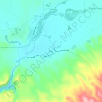
Name: Ophir topographic map, elevation, terrain.
Average elevation: 338 m
Minimum elevation: 288 m
Maximum elevation: 490 m
Central Otago District trails, hiking, mountain biking, running and outdoor activities
Thank you for supporting this site ❤️
Make a donation
Make a donation
Other topographic maps
Click on a map to view its topography, its elevation and its terrain.
Blue Lake
New Zealand > Otago > Central Otago District > Vincent Community > Saint Bathans
Average elevation: 605 m