
Thank you for supporting this site ❤️
Make a donation
Make a donation
Sicilì topographic map
Click on the map to display elevation.
Thank you for supporting this site ❤️
Make a donation
Make a donation
About this map
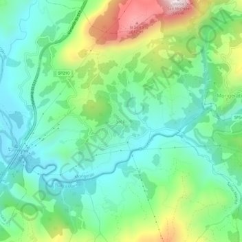
Name: Sicilì topographic map, elevation, terrain.
Location: Sicilì, Morigerati, Salerno, Campania, Italy (40.11566 15.51179 40.15566 15.55179)
Average elevation: 228 m
Minimum elevation: 34 m
Maximum elevation: 688 m
Thank you for supporting this site ❤️
Make a donation
Make a donation
Other topographic maps
Click on a map to view its topography, its elevation and its terrain.
Acerno
The communal territory has an elevation varying between 400 and 1790 metres above sea level. Outside of the town itself it is entirely uninhabited by humans: there are no satellite hamlets or even scattered dwellings under permanent habitation. It is rich in flora, however, with forests of maple, oak,…
Average elevation: 954 m
Thank you for supporting this site ❤️
Make a donation
Make a donation
Thank you for supporting this site ❤️
Make a donation
Make a donation
Thank you for supporting this site ❤️
Make a donation
Make a donation