
Thank you for supporting this site ❤️
Make a donation
Make a donation
Tabubil topographic map
Click on the map to display elevation.
Thank you for supporting this site ❤️
Make a donation
Make a donation
About this map
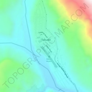
Name: Tabubil topographic map, elevation, terrain.
Location: Tabubil, Western, Southern Region, Papua New Guinea (-5.29654 141.21810 -5.25278 141.24111)
Average elevation: 591 m
Minimum elevation: 372 m
Maximum elevation: 1,350 m
Thank you for supporting this site ❤️
Make a donation
Make a donation
Other topographic maps
Click on a map to view its topography, its elevation and its terrain.