
Make a donation
Glen Croe topographic map
Click on the map to display elevation.
Make a donation
About this map
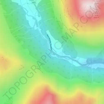
Name: Glen Croe topographic map, elevation, terrain.
Location: Glen Croe, Scotland, G83 7AS, United Kingdom (56.19130 -4.83712 56.21130 -4.81712)
Average elevation: 355 m
Minimum elevation: 55 m
Maximum elevation: 870 m
Make a donation
Other topographic maps
Click on a map to view its topography, its elevation and its terrain.
Orkney Islands
United Kingdom > Scotland > Orkney Islands
The southern group of islands surrounds Scapa Flow. Hoy, to the west, is the second largest of the Orkney Isles and Ward Hill at its northern end is the highest elevation in the archipelago. The Old Man of Hoy is a well-known seastack. Graemsay and Flotta are both linked by ferry to the Mainland and Hoy, and…
Average elevation: 9 m
Make a donation
City of Edinburgh
Edinburgh has been popularly called the Athens of the North since the early 19th century. References to Athens, such as Athens of Britain and Modern Athens, had been made as early as the 1760s. The similarities were seen to be topographical but also intellectual. Edinburgh's Castle Rock reminded returning…
Average elevation: 118 m
Make a donation
Skye
United Kingdom > Scotland > Highland
Beyond Loch Snizort to the west of Trotternish is the Waternish peninsula, which ends in Ardmore Point's double rock arch. Duirinish peninsula is separated from Waternish by Loch Dunvegan, which contains the island of Isay. It is ringed by sea cliffs that reach 296 metres (971 feet) on the west at Waterstein…
Average elevation: 63 m
Orkney Islands
The southern group of islands surrounds Scapa Flow. Hoy, to the west, is the second largest of the Orkney Isles and Ward Hill at its northern end is the highest elevation in the archipelago. The Old Man of Hoy is a well-known seastack. Graemsay and Flotta are both linked by ferry to the Mainland and Hoy, and…
Average elevation: 7 m
Aberdeen City
Two weather stations collect climate data for the area, Aberdeen/Dyce Airport, and Craibstone. Both are about 4+1⁄2 miles (7 km) to the north west of the city centre, and given that they are in close proximity to each other, exhibit very similar climatic regimes. Dyce tends to have marginally warmer daytime…
Average elevation: 46 m
Make a donation
Shetland
Walter Scott's 1822 novel The Pirate is set in "a remote part of Shetland", and was inspired by his 1814 visit to the islands. The name Jarlshof meaning "Earl's Mansion" is a coinage of his. Robert Cowie, a doctor born in Lerwick published the 1874 work.Shetland: Descriptive and Historical; Being a Graduation…
Average elevation: 4 m
Make a donation
Isle of Arran
United Kingdom > Scotland > North Ayrshire
The island has three endemic species of tree, the Arran whitebeams. These trees are the Scottish or Arran whitebeam (Sorbus arranensis), the bastard mountain ash or cut-leaved whitebeam (Sorbus pseudofennica) and the Catacol whitebeam (Sorbus pseudomeinichii). If rarity is measured by numbers alone they are…
Average elevation: 98 m
Strathclyde Loch
United Kingdom > Scotland > Bellshill > Douglas Park Cottages
Average elevation: 38 m
Make a donation
North Rona
United Kingdom > Scotland > Western Isles
Rona (Scottish Gaelic: Rònaigh) is an uninhabited Scottish island in the North Atlantic. It is often referred to as North Rona to distinguish it from the island of South Rona in the Inner Hebrides. It has an area of 109 hectares (270 acres) and a maximum elevation of 108 metres (354 ft).
Average elevation: 4 m
Make a donation
Make a donation
Angus
Angus can be split into three geographic areas. To the north and west, the topography is mountainous. This is the area of the Grampian Mountains, Mounth hills and Five Glens of Angus, which is sparsely populated and where the main industry is hill farming. Glas Maol – the highest point in Angus at 1,068 m…
Average elevation: 254 m
Make a donation
Caithness
Caithness extends about 30 miles (48 km) north-south and about 30 miles (48 km) east-west, with a roughly triangular-shaped area of about 712 sq mi (1,840 km2). The topography is generally flat, in contrast to the majority of the remainder of the North of Scotland. Until the latter part of the 20th century…
Average elevation: 79 m
South Ayrshire
The number of hours of natural sunshine in South Ayrshire is controlled by the length of day and by cloudiness. In general, December is the dullest month and May or June the sunniest. Sunshine duration decreases with increasing altitude, increasing latitude and distance from the coast. Local topography also…
Average elevation: 151 m
Make a donation
East Ayrshire
East Ayrshire is located on the west coat of Scotland, sharing borders with the following neighbouring council areas; North Ayrshire, South Ayrshire, Dumfries and Galloway, East Renfrewshire and South Lanarkshire. Blackcraig Hill reaches an elevation of 2,298 feet (700 metres), the highest peak in East…
Average elevation: 225 m
Make a donation
Make a donation
Ailsa Craig
In a small glen above Ailsa Castle, a small freshwater body known as the Garry Loch is located at an altitude of 247 m (810 ft), with a depth of at least 17 feet.
Average elevation: 14 m
Make a donation
Make a donation
Make a donation
Make a donation
Make a donation
Make a donation
Make a donation
Loch Lomond and The Trossachs National Park
United Kingdom > Scotland > Stirling
The park straddles the Highland Boundary Fault, which divides it into two distinct regions - lowland and highland - that differ in underlying geology, soil types and topography. The change in rock type can most clearly be seen at Loch Lomond itself, as the fault runs across the islands of Inchmurrin, Creinch,…
Average elevation: 291 m
Pentland Hills Regional Park
United Kingdom > Scotland > Edinburgh > Peggyslea
Average elevation: 249 m
Make a donation
Lerwick
United Kingdom > Scotland > Shetland
Lerwick has transitioned from a subpolar oceanic climate (Cfc) to a maritime climate (Cfb) with cool to cold temperatures all year long. The lack of trees reflects the latter type. This is particularly pronounced by virtue of Lerwick being on the coast of an island, so even extreme temperature records are…
Average elevation: 34 m
Cumbernauld
United Kingdom > Scotland > North Lanarkshire
Cumbernauld's name probably comes from the Gaelic comar nan allt, meaning "meeting of the burns or streams". There are differing views as to the etymology of this. One theory is that from its high point in the Central Belt, its streams flow both west to the River Clyde and east to the Firth of Forth so…
Average elevation: 113 m
Make a donation
Craigmaddie Reservoir
United Kingdom > Scotland > East Dunbartonshire > Milngavie
Average elevation: 97 m
The Birks of Aberfeldy
United Kingdom > Scotland > Perth and Kinross > Aberfeldy
Average elevation: 222 m
Make a donation
Make a donation
Make a donation
Make a donation
Make a donation