
Thank you for supporting this site ❤️
Make a donation
Make a donation
Wayne County topographic map
Click on the map to display elevation.
Thank you for supporting this site ❤️
Make a donation
Make a donation
Wayne County
The highest elevation in the county, 2,659 ft (810 m), is the summit of Mount Ararat in Orson. Two other summits at the north end of the same ridge also exceed 2,640 ft (800 m) in elevation. The county's lowest point, at approximately 680 ft (210 m) above sea level, is along the Delaware, near Wayne County's border with Pike County, Pennsylvania.
Thank you for supporting this site ❤️
Make a donation
Make a donation
About this map
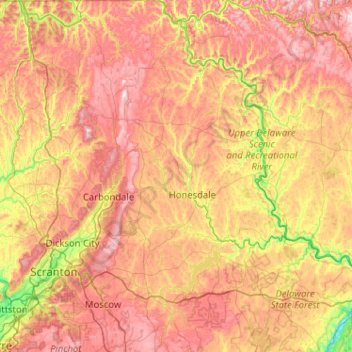
Name: Wayne County topographic map, elevation, terrain.
Location: Wayne County, Pennsylvania, United States (41.23232 -75.50581 41.99950 -75.04361)
Average elevation: 436 m
Minimum elevation: 112 m
Maximum elevation: 800 m
Thank you for supporting this site ❤️
Make a donation
Make a donation