
Thank you for supporting this site ❤️
Make a donation
Make a donation
Lattimore topographic map
Click on the map to display elevation.
Thank you for supporting this site ❤️
Make a donation
Make a donation
About this map
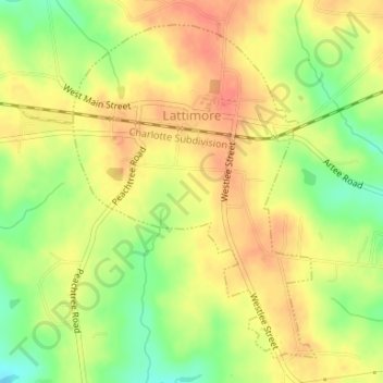
Name: Lattimore topographic map, elevation, terrain.
Location: Lattimore, Cleveland County, North Carolina, United States (35.30101 -81.67096 35.32458 -81.64991)
Average elevation: 271 m
Minimum elevation: 241 m
Maximum elevation: 291 m
Thank you for supporting this site ❤️
Make a donation
Make a donation
Other topographic maps
Click on a map to view its topography, its elevation and its terrain.
Thank you for supporting this site ❤️
Make a donation
Make a donation
Osborne Apartments
United States > North Carolina > Cleveland County > Shelby
Average elevation: 256 m