
Thank you for supporting this site ❤️
Make a donation
Make a donation
Passaic topographic map
Click on the map to display elevation.
Thank you for supporting this site ❤️
Make a donation
Make a donation
About this map
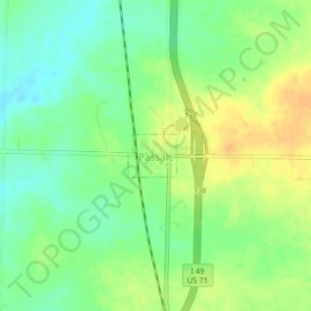
Name: Passaic topographic map, elevation, terrain.
Location: Passaic, Bates County, Missouri, United States (38.32020 -94.35136 38.32394 -94.34597)
Average elevation: 264 m
Minimum elevation: 249 m
Maximum elevation: 281 m
Thank you for supporting this site ❤️
Make a donation
Make a donation
Other topographic maps
Click on a map to view its topography, its elevation and its terrain.