
Thank you for supporting this site ❤️
Make a donation
Make a donation
New Strawn topographic map
Click on the map to display elevation.
Thank you for supporting this site ❤️
Make a donation
Make a donation
About this map
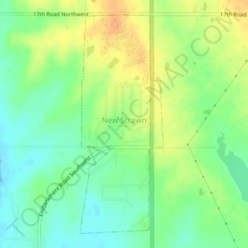
Name: New Strawn topographic map, elevation, terrain.
Location: New Strawn, Coffey County, Kansas, United States (38.25014 -95.74807 38.27398 -95.73648)
Average elevation: 336 m
Minimum elevation: 320 m
Maximum elevation: 355 m
Thank you for supporting this site ❤️
Make a donation
Make a donation