
Kinghorn topographic map
Interactive map
Click on the map to display elevation.
About this map
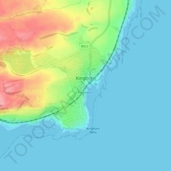
Name: Kinghorn topographic map, elevation, terrain.
Location: Kinghorn, Fife, Scotland, United Kingdom (56.05976 -3.20645 56.07933 -3.16034)
Average elevation: 30 m
Minimum elevation: -1 m
Maximum elevation: 114 m
Other topographic maps
Click on a map to view its topography, its elevation and its terrain.
Auchtermuchty
United Kingdom > Scotland > Fife
Auchtermuchty, Fife, Scotland, KY14 7AP, United Kingdom
Average elevation: 108 m
Cupar
United Kingdom > Scotland > Fife
Cupar, Fife, Scotland, KY15 4BP, United Kingdom
Average elevation: 75 m
Auchtertool
United Kingdom > Scotland > Fife
Auchtertool, Fife, Scotland, United Kingdom
Average elevation: 113 m
Crail
United Kingdom > Scotland > Fife
Crail, Fife, Scotland, KY10 3UG, United Kingdom
Average elevation: 21 m
Rankeilour
United Kingdom > Scotland > Fife > Springfield
Rankeilour, Springfield, Fife, Scotland, KY15 5RE, United Kingdom
Average elevation: 48 m
Dunfermline
United Kingdom > Scotland > Fife
Dunfermline, Fife, Scotland, United Kingdom
Average elevation: 114 m
Falkland
United Kingdom > Scotland > Fife
Falkland, Fife, Scotland, KY15 7BU, United Kingdom
Average elevation: 133 m
Leuchars
United Kingdom > Scotland > Fife > Leuchars
Leuchars, Fife, Scotland, KY16 0HH, United Kingdom
Average elevation: 22 m
Tayport
United Kingdom > Scotland > Fife
Tayport, Fife, Scotland, DD6 9AE, United Kingdom
Average elevation: 22 m