
Thank you for supporting this site ❤️
Make a donation
Make a donation
Castroncelos topographic map
Click on the map to display elevation.
Thank you for supporting this site ❤️
Make a donation
Make a donation
About this map
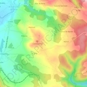
Name: Castroncelos topographic map, elevation, terrain.
Average elevation: 461 m
Minimum elevation: 377 m
Maximum elevation: 554 m
Thank you for supporting this site ❤️
Make a donation
Make a donation
Other topographic maps
Click on a map to view its topography, its elevation and its terrain.
Thank you for supporting this site ❤️
Make a donation
Make a donation
Pacios de Veiga
España > Galicia > Tierra de Lemos > A Pobra do Brollón > Pacios de Veiga
Average elevation: 469 m