
Make a donation
Morris County topographic map
Click on the map to display elevation.
Make a donation
Morris County
Morris County, New Jersey, features a diverse topography characterized by rolling hills, ridges, and valleys. The western part of the county is dominated by the New Jersey Highlands, part of the Appalachian Mountains, with elevations reaching approximately 1,395 feet (425 meters) above sea level near Pine Swamp in Jefferson Township. In contrast, the eastern section is part of the Piedmont Plateau, offering gentler slopes and elevations around 160 feet (49 meters) at the confluence of the Passaic and Pompton rivers, and featuring the Watchung Mountains, which include prominent ridges. These ridges are composed of basaltic rock formations and extend over 40 miles (64 km) from Somerset County in the southwest to Bergen County in the northeast. The county's terrain is further shaped by several rivers, including the Passaic, Pompton, and Rockaway Rivers, which have carved valleys and floodplains through the landscape. Additionally, glacial activity during the last Ice Age has left behind features such as the Great Swamp, a remnant of the prehistoric Glacial Lake Passaic. Overall, Morris County's topography offers a varied landscape, from the rugged highlands in the west to the rolling hills and river valleys in the east.
Make a donation
About this map
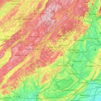
Name: Morris County topographic map, elevation, terrain.
Location: Morris County, New Jersey, United States (40.64952 -74.88877 41.08600 -74.26664)
Average elevation: 182 m
Minimum elevation: 9 m
Maximum elevation: 426 m
Make a donation
Other topographic maps
Click on a map to view its topography, its elevation and its terrain.
North Hudson Park
United States > New Jersey > Hudson County > North Bergen > Hudson Heights
Average elevation: 41 m
Make a donation
Pleasant Valley
United States > New Jersey > Morris County > Mendham Township
Average elevation: 156 m
Make a donation
East Trenton Heights
United States > New Jersey > Mercer County > Hamilton Township
Average elevation: 22 m
Lake Parsippany
United States > New Jersey > Morris County > Parsippany-Troy Hills
Average elevation: 93 m
Make a donation
North Stelton
United States > New Jersey > Middlesex County > Piscataway Township
Average elevation: 29 m
Make a donation
Randolphville
United States > New Jersey > Middlesex County > Piscataway Township
Average elevation: 26 m
Randolphville
United States > New Jersey > Middlesex County > Piscataway Township
Average elevation: 26 m
Paulas Corners
United States > New Jersey > Middlesex County > East Brunswick Township
Average elevation: 29 m
Make a donation
Lawrence Brook Manor
United States > New Jersey > Middlesex County > East Brunswick Township
Average elevation: 19 m
Robinsville
United States > New Jersey > Monmouth County > Upper Freehold Township
Average elevation: 56 m
Croxton
United States > New Jersey > Hudson County > Jersey City > Journal Square
Average elevation: 16 m
Make a donation
Wertsville
United States > New Jersey > Hunterdon County > East Amwell Township
Average elevation: 72 m
Possumtown
United States > New Jersey > Middlesex County > Piscataway Township
Average elevation: 19 m
Homes Mills
United States > New Jersey > Monmouth County > Upper Freehold Township
Average elevation: 34 m
Make a donation
Charleston East
United States > New Jersey > Camden County > Cherry Hill Township
Average elevation: 23 m
Van Marters Corner
United States > New Jersey > Monmouth County > Hazlet Township
Average elevation: 6 m
Make a donation
Make a donation
Basking Ridge
United States > New Jersey > Somerset County > Bernards Township
Average elevation: 98 m
Make a donation
Stow Acres
United States > New Jersey > Burlington County > Evesham Township > Marlton
Average elevation: 24 m
Make a donation
Woolwich Township
United States > New Jersey > Gloucester County > Woolwich Township
Average elevation: 23 m
Make a donation
Make a donation
Make a donation
Rahway River West Branch
United States > New Jersey > Essex County > Short Hills
Average elevation: 73 m
Make a donation
Columbia Lakes
United States > New Jersey > Camden County > Cherry Hill Township
Average elevation: 17 m
Remsterville
United States > New Jersey > Salem County > Alloway Township > Alloway Township
Average elevation: 15 m
Make a donation
Powder Mill Pond Dam
United States > New Jersey > Morris County > Parsippany-Troy Hills > Tabor
Average elevation: 178 m
Upper Mill
United States > New Jersey > Burlington County > Pemberton Township
Average elevation: 31 m
Make a donation
Freneau Woods Park
United States > New Jersey > Monmouth County > Aberdeen Township > Henningers Mill
Average elevation: 23 m
Make a donation
Mount Royal
United States > New Jersey > Gloucester County > East Greenwich Township
Average elevation: 11 m
Lincoln
United States > New Jersey > Gloucester County > South Harrison Township
Average elevation: 37 m
Make a donation
Washington Corner
United States > New Jersey > Morris County > Mendham Township
Average elevation: 174 m
Make a donation
Fostertown
United States > New Jersey > Burlington County > Lumberton Township
Average elevation: 14 m
Elmer B Boyd Park
United States > New Jersey > Middlesex County > New Brunswick > Feaster Park
Average elevation: 22 m
Make a donation
Make a donation
Make a donation
Make a donation
Schooleys Mountain
United States > New Jersey > Morris County > Washington Township
Average elevation: 293 m
Make a donation