
Rimbeck topographic map
Interactive map
Click on the map to display elevation.
About this map
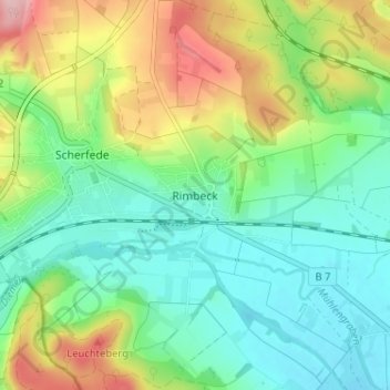
Name: Rimbeck topographic map, elevation, terrain.
Location: Rimbeck, Warburg, Kreis Höxter, Nordrhein-Westfalen, Deutschland (51.50743 9.02854 51.54743 9.06854)
Average elevation: 231 m
Minimum elevation: 174 m
Maximum elevation: 348 m
Other topographic maps
Click on a map to view its topography, its elevation and its terrain.
Herlinghausen
Deutschland > Nordrhein-Westfalen > Kreis Höxter > Warburg
Herlinghausen, Warburg, Kreis Höxter, Nordrhein-Westfalen, 34479, Deutschland
Average elevation: 227 m
Calenberg
Deutschland > Nordrhein-Westfalen > Kreis Höxter > Warburg
Calenberg, Warburg, Kreis Höxter, Nordrhein-Westfalen, 34479, Deutschland
Average elevation: 218 m
Gaulskopf
Deutschland > Nordrhein-Westfalen > Kreis Höxter > Warburg
Gaulskopf, Warburg, Kreis Höxter, Nordrhein-Westfalen, Deutschland
Average elevation: 253 m
Scherfede
Deutschland > Nordrhein-Westfalen > Kreis Höxter > Warburg
Scherfede, Warburg, Kreis Höxter, Nordrhein-Westfalen, Deutschland
Average elevation: 300 m
Ossendorf
Deutschland > Nordrhein-Westfalen > Kreis Höxter > Warburg
Ossendorf, Warburg, Kreis Höxter, Nordrhein-Westfalen, 34414, Deutschland
Average elevation: 200 m
Bonenburg
Deutschland > Nordrhein-Westfalen > Kreis Höxter > Warburg
Bonenburg, Warburg, Kreis Höxter, Nordrhein-Westfalen, Deutschland
Average elevation: 293 m